

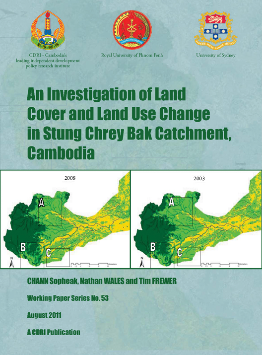
An Investigation of Land Cover and Land Use Change in Stung Chrey Bak Catchment, Cambodia
Abstract/Summary
This working paper presents the findings of research undertaken on
land use and land cover (LULC) change in Cambodia, with a focus on water
resource development and local livelihoods in Stung Chrey Bak catchment,
Kompong Chhnang province. The research aims to provide improved information of
LULC to researchers, policy makers, and other stakeholders and was undertaken
as one of three research components of the Water Resource Management and
Research Capacity Development Programme (WRMRCDP).
This study investigates the interaction between water resources,
LULC, and local livelihoods over two decades within an agricultural catchment
in the upper and middle sections of Stung Chrey Bak (a tributary of the Tonle
Sap) catchment. The time period examined was 1989 to 2008. Research focused on
two aspects: i) investigation of the physical characteristics of land cover
changes using satellite image classifications; and, ii) interviews and field observations
at the local level and qualitative analysis of on the ground changes. Changes
in land cover were quantified using satellite remote sensing imagery; however,
drivers of changes in land use, including land conversion, were harder to
measure through quantitative analysis. The qualitative research aimed not only
at understanding changes on the ground, but also the possible reasons or
drivers behind such change. By combining qualitative and quantitative research
a more comprehensive understanding of change at different spatial locations and
across multi-temporal periods was gained.
The results of this research indicate that LULC across the study
site has changed considerably over the last two decades. The three satellite
image classifications in 1989, 2003 and 2008 suggest that LULC has changed
across the majority of the catchment. Fragmentation and a decline in the
quality of evergreen forest has occurred in the upstream part of the catchment,
though some areas of evergreen forest have been retained in areas which
correspond closely with the boundary of the Phnom Aural Wildlife Sanctuary. The
field interviews revealed that both quality and quantity of the evergreen
forest had declined over the study period within most of the Chrey Bak
catchment. Findings also showed a steady decline of remaining secondary forest
in the midstream and some upstream areas. Such disturbance is a result of forest
encroachment and illegal logging by local people and outsiders1, charcoal
production, and commercial agriculture (large scale plantations). The
implications of such disturbances must be taken into consideration if
sustainable catchment management objectives across the catchment are to be
achieved.
Various players have contributed to LULC change across the
catchment. Poorly conceived water resource development and agricultural
expansion during the Khmer Rouge (KR) period from 1975 to 1979 influenced the
patterns of land use and land cover seen today2. The KR, which occupied some
areas in the study site until the 1990s, contributed to rapid forest clearing, including
the removal of high value timber, particularly in the upstream catchment.
Institutional and organisational changes, including the adoption
of the Land Laws in 1992 and 2001, and the Laws on Forestry in 2002 and 2005,
have also shaped current land use practices and attitudes towards land and
forests. For example, the 1992 Land Law allowed people who cultivated a
specific plot for five years or longer to claim ownership of that land. 1 It
was unclear who this refers to but may include external operators from as far
afield as Phnom Penh. 2 Imagery for the period prior to 1975 showing forest
cover and land use was not available at the time of this research. Such
claims commonly led to conversion of land from secondary forest to rice fields,
the results of which are still evident across the catchment today. In addition,
the 2002 Law on Forestry has provided improved security to local communities
throughout Cambodia by allowing the government to confiscate land that has
otherwise been claimed illegally through land grabbing. Other factors that have
influenced LULC change in the catchment include land grabbing, charcoal
production, illegal logging and economic land concessions.
Even as irrigation system development played a minor role in
agricultural land expansion, the expansion of irrigated land for rice
production and other more water intensive agriculture poses a threat to
hydrological processes within the catchment, in particular the availability of water
resources. The irrigation system is constrained by water availability, but
irrigation demand is growing with the potential to create increased competition
for water between upstream and downstream users. Concerns over increased
competition for water were a key issue raised in the interviews for this
research. Changes to land use and land cover have the potential to impact on
water availability and quality, limiting the opportunities for more sustainable
catchment management.
The key messages of this research are that:
·
Effective methods to assess land use and land cover change in
Cambodia are needed to ensure that suitable data is available for sustainable catchment
management and monitoring.
·
Land use and land cover
change assessment and monitoring need to involve technically sophisticated
quantitative methods such as remote sensing; however, these methods alone do
not provide a comprehensive tool for measuring land cover change.
· A combination of quantitative methods such as remote sensing and qualitative methods such as interviews is essential to provide a complete picture of land use and land cover change in Cambodia.
Key
actions that the Cambodian government can take to improve land use and land
cover data are:
·
Encourage and invest in the integration of high quality technical
quantitative and qualitative approaches using local knowledge and ground
truthing to avoid over simplification and to understand local nuances and
specificity. Attention should be paid to strengthening local expertise in LCLU
change analysis and ensuring quality data.
·
Draw upon the Royal University Phnom Penh (RUPP) and CDRI for the
capacities that these institutions have built through this project by using the
mixed methods approach to advance knowledge and understanding of LULC change in
Cambodia.
Related Publications
Contract Farming in Cambodia: Good Practices and Lessons Learned
01-Jan-2021